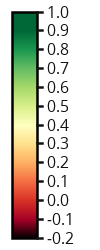
Satellite:Sentinel-2
Source:Sentinel Hub service
Resolution:10m x 10m
Description:True color composite uses visible light bands red (B04), green (B03) and blue (B02) in the corresponding red, green and blue color channels, resulting in a natural colored result, that is a good representation of the Earth as humans would see it naturally.
Satellite:Sentinel-2
Source:Sentinel Hub service
Resolution:20m x 20m
Description:A new moisture index, the Normalized Multi-bandDrought Index (NMDI), is proposed for remote sensing of both soil and vegetation water content from space.
Legend:
Interpretation:The preliminary results suggest that for bare soil or weakly vegetated areas, a pixel will be mapped as dry soil condition if the NMDI is ≥ 0.7, intermediate if NMDI is within the range of 0.6 to 0.7, and wet if NMDI is < 0.6. While for heavily vegetated areas with LAI ≥ 2, the performance of NMDI is similar to NDWI and NDII. Therefore, by combining information from multiple NIRand SWIR channels, NMDI has enhanced the sensitivity todrought severity, and is well suited to estimate water contentfor both soil and vegetations. Source
Satellite:Landsat 8
Source:Sentinel Hub service
Resolution:100m x 100m
Description:This thermal visualization is based on band 10 (a band is a region of the electromagnetic spectrum; a satellite sensor can image Earth in different bands). At the central wavelength of 10895 nm it measures in the thermal infrared, or TIR. Instead of measuring the temperature of the air, like weather stations do, band 10 reports on the ground itself, which is often much hotter. Thermal band 10 is useful in providing surface temperatures and is collected with a 100-meter resolution.
Legend:
Satellite:Sentinel-2
Source:Sentinel Hub service
Resolution:10m x 10m
Description: NDVI (Normalized Difference Vegetation Index) describes the vigour level of the crop. The interpretation of the absolute value of the NDVI is highly informative, as it allows the immediate recognition of the areas of the farm or field that have problems. The NDVI is a simple index to interpret: its values vary between -1 and 1.
Legend:
Interpretation: Source
Source
NDVI INTERPRETATION
0 – 0-1 Bare soil
0.1 – 0.2 Almost absent canopy cover
0.2 – 0.3 Very low canopy cover
0.3 – 0.4 Low canopy cover, low vigour or very low canopy cover, high vigour
0.4 – 0.5 Mid-low canopy cover, low vigour or low canopy cover, high vigour
0.5 – 0.6 Average canopy cover, low vigour or mid-low canopy cover, high vigour
0.6 – 0.7 Mid-high canopy cover, low vigour or average canopy cover, high vigour
0.7 – 0.8 High canopy cover, high vigour
0.8 – 0.9 Very high canopy cover, very high vigour
0.9 – 1 Total canopy cover, very high vigour
Satellite:Sentinel-2
Source:Sentinel Hub service
Resolution:20m x 20m
Description:The NDMI (Normalized Difference Moisture Index) describes the crop’s water stress level. The interpretation of the absolute value of the NDMI makes possible to immediately recognize the areas of the farm or field with water stress problems. NDMI is easy to interpret: its values vary between -1 and 1.
Legend:
Interpretation:
NDMI INTERPRETATION
-1 – -0.8 Bare soil
-0.8 – -0.6 Almost absent canopy cover
-0.6 – -0.4 Very low canopy cover
-0.4 – -0.2 Low canopy cover, dry or very low canopy cover, wet
-0.2 – 0 Mid-low canopy cover, high water stress or low canopy cover, low water stress
  1. 0.2
Average canopy cover, high water stress or mid-low canopy cover, low water stress
0.2 – 0.4 Mid-high canopy cover, high water stress or average canopy cover, low water stress
0.4 – 0.6 High canopy cover, no water stress
0.6 – 0.8 Very high canopy cover, no water stress
0.8 – 1 Total canopy cover, no water stress/ waterlogging
Source
Source:irdat
Source link:http://irdat.regione.fvg.it/consultatore-dati-ambientali-territoriali/detail/irdat/11451/direct?language=en
Scale:1:50.000
Area:Provinces of Gorizia and Trieste, Italy
Description:Map of the soils in the 1:50.000 scale of the provinces of Gorizia and Trieste with percentile frequencies of the soils, their synthetic description and FAO classification
Source:irdat
Source link:http://irdat.regione.fvg.it/consultatore-dati-ambientali-territoriali/detail/irdat/11457/direct?language=en
Scale:1:100.000
Area:Province of Pordenone, Italy
Description:Map of the soils at 1:100.000 scale of the plain and the Pordenone hills with percentile frequencies of the soils, their synthetic description and FAO classification
Source:ARSO
Source link: http://gis.arso.gov.si/geoportal/catalog/search/resource/details.page?uuid=%7BF56A9CCB-661B-47AB-9BC0-ECA42E00FC23%7D
Scale:1:25.000
Area:Slovenia
Description:Map of the soils at 1:25.000 scale of the Slovenian surface.
Source:DRSV
Source link: https://gisserver.gov.si/arcgis/rest/services/DRSV/IKPN_D48/MapServer/406
Area:Slovenia
Description:Areas covered by 10-years floods
Source:DRSV
Source link: https://gisserver.gov.si/arcgis/rest/services/DRSV/IKPN_D48/MapServer/406
Area:Slovenia
Description:Areas covered by 10-years floods (vector layer)
Source:ARSO
Source link: http://gis.arso.gov.si/geoportal/catalog/search/resource/details.page?uuid=%7BDBC58E64-8EC9-4A05-A5E4-579C3501E2B2%7D
Area:Slovenia
Description:Water bodies
Source:irdat
Source link: http://irdat.regione.fvg.it/consultatore-dati-ambientali-territoriali/detail/irdat/9848/direct?language=en
Area:Friuli Venezia Giulia Region, Italy
Description:A surface water body relating to Watercourses is a distinguished and significant element of surface water, such as a stream, river or canal, part of a stream, river or canal (European Directive 2000/60)
Source:irdat
Source link: http://irdat.regione.fvg.it/consultatore-dati-ambientali-territoriali/detail/irdat/9847/direct?language=en
Area:Friuli Venezia Giulia Region, Italy
Description:Groundwater bodies
Source:ARSO
Source link: http://gis.arso.gov.si/geoportal/catalog/search/resource/details.page?uuid=%7BB879E449-1A6A-42BE-83C4-3BA27D6EDC72%7D
Area:Slovenia
Description:Groundwater bodies
Source:ARSO
Source link: http://gis.arso.gov.si/geoportal/catalog/search/resource/details.page?uuid=%7BB1F61E2A-A8F0-4484-A02C-1382EFD17E92%7D
Area:Slovenia
Description:Groundwater reservoirs
Source:DRSV
Source link: https://gisserver.gov.si/arcgis/rest/services/DRSV/Varstvo_voda_D48/MapServer/201
Area:Slovenia
Description:Drinking water safeguard zones based on municipal ordinance
Source:irdat
Source link: http://irdat.regione.fvg.it/consultatore-dati-ambientali-territoriali/detail/irdat/9715/direct?language=en
Area:Friuli Venezia Giulia Region, Italy
Description:Provide geographical evidence of protected areas of drinking water
Source:ARSO
Source link: http://gis.arso.gov.si/geoportal/catalog/search/resource/details.page?uuid=%7B87051880-D95D-4730-9F5A-5E1D3D4386EA%7D
Area:Slovenia
Description:Caves as ecological important areas
Source:Agenzia delle Entrate
Source link:https://www.agenziaentrate.gov.it/portale/documents/20143/260417/Manuale+consultazione+cartografia_Documentazione+descrittiva+del+servizio+di+consultazione+della+cartografia+catastale+20180611.pdf/35e955f7-2344-56c8-1157-8f7567531660
Scale:1:5.000
Area:Italy
Description:Italian cadastre
Source:GURS
Source link:https://eprostor.gov.si/imps/srv/eng/catalog.search#/metadata/3e0b727e-49d5-4c7f-835b-823c5392a307
Area:Slovenia
Description:Land Cadastre is an official register of land parcels. Land Cadastre includes up-to-date information on parcels and includes the collection of documentation and information necessary for historical track changes of parcels. The collection of documentation (in analogue and digital form) includes files and other documents, that were originally used for the official registration of parcels. The collection of documentation is stored permanently.
Source:Ministry of Argiculture, Forestry and Food (Slovenia)
Source link:https://podatki.gov.si/dataset/evidenca-dejanske-rabe-kmetijskih-in-gozdnih-zemljisc1
Area:Slovenia
Description:Land use
Source:Ministry of Argiculture, Forestry and Food (Slovenia)
Source link:https://podatki.gov.si/dataset/identifikacijski-sistem-za-zemljisca-blok-gerk
Area:Slovenia
Description:Agricultural holdings
Source:ARSO
Source link:http://gis.arso.gov.si/geoportal/catalog/search/resource/details.page?uuid=%7B57B7C2AE-B628-4C50-B943-D0E0BE496D79%7D
Area:Slovenia
Description:Natura 2000 is a European network of protected nature areas where certain species of animal and their natural habitats are protected in order to preserve biodiversity.
Source:ARSO
Source link:http://gis.arso.gov.si/geoportal/catalog/search/resource/details.page?uuid=%7B6DAECEBC-2BDC-48D6-A61F-D709B791006D%7D
Area:Slovenia
Description:Ecologically important areas
Source:ARSO
Source link:http://gis.arso.gov.si/geoportal/catalog/search/resource/details.page?uuid=%7BD007700F-CE87-4003-8CFA-81B22D11A8A5%7D
Area:Slovenia
Description:Valuable natural features
Source:ARSO, ESA
Source link:http://gis.arso.gov.si/geoportal/catalog/search/resource/details.page?uuid=%7B4ECD80B7-9FB4-4DCB-A9EB-9B8414A31FEE%7D
Resolution:25 m
Area:Slovenia - West, Italy - East
Description:Mean integrated daily solar irradiation index values from gray (less solar daily irradiation) to red (lot of solar daily irradiation).
Resolution:25 m
Area:Slovenia - West, Italy - East
Description:Terrain slope values from green (plane) to red (slope).
Resolution:25 m
Area:Slovenia - West, Italy - East
Description:Terrain slope values sorted in classes from green (plane) to red (slope).
Area:Slovenia - West, Italy - East
Description:Shaded relief, or hillshading, is a technique where a lighting effect is added to a map based on elevation variations within the landscape. It provides a clearer picture of the topography by mimicing the sun’s effects (illumination, shading and shadows) on hills and valleys.
Source:GURS
Source link:https://www.e-prostor.gov.si/zbirke-prostorskih-podatkov/topografski-in-kartografski-podatki/ortofoto/
Resolution:0,5 m
Area:Slovenia
Description:An orthophoto is an aerial photograph that has been geometrically corrected or 'ortho-rectified' such that the scale of the photograph is uniform and utilised in the same manner as a map.
Source:Agenzia per l'Italia Digitale
Source link:https://geodati.gov.it/resource/id/m_amte:299FN3:eda6494c-b619-441a-a2d7-4097f8cde540
Resolution:0,5 m
Area:Italy
Description:An orthophoto is an aerial photograph that has been geometrically corrected or 'ortho-rectified' such that the scale of the photograph is uniform and utilised in the same manner as a map.
Source:OpenStreetMap
Source link:https://www.openstreetmap.org/
Area:World
Description:World map used as chartographic basis of project area.
Source:Ministry of Argiculture, Forestry and Food (Slovenia), OpenStreetMap
Source link:https://podatki.gov.si/dataset/identifikacijski-sistem-za-zemljisca-blok-gerk
Area:Slovenia - West, Italy - East
Description:Overlay mask to expose vineyard areas. Enables to read values of other layers focused on vineyard areas. Mask is based on GERK vineyard areas on Slovenian side and OSM vineyard areas on Italian side.
Area:Slovenia - West, Italy - East
Description:Locations of vineyards involved in Acquavitis project.